LURU Trees · Bengaluru
Where Bengaluru still has trees.
Bengaluru canopy across four year ranges
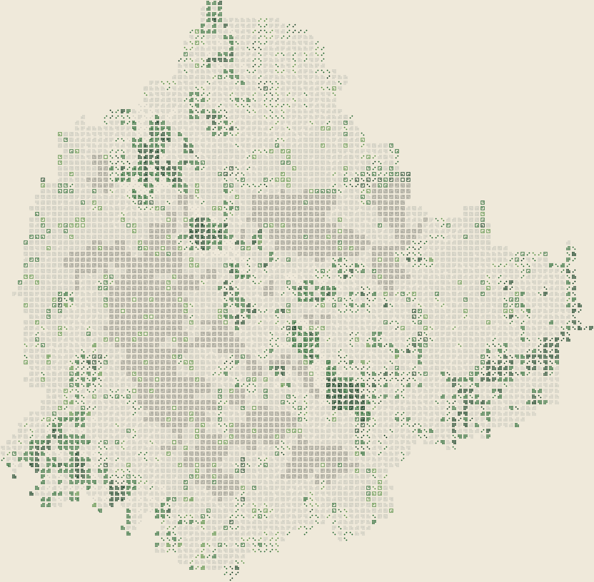
2021–25
dry-season map
Loading the map
Hold the map to compare with 2001–05
2001–05 · Where green appeared
This is where the green sits.
One square is about 340 metres wide. The green is not spread evenly. It gathers inside defence compounds, campuses, Palace grounds and big parks.
2006–10 · Drier years
Rain can change the whole picture.
Trees are only part of what looks green from space. Grass, scrub and fields respond quickly to rain. In dry years, the map can lose colour without losing the same amount of tree cover.
2016–20 · Wetter years
Green comes back into the reading.
That does not mean all those trees grew back. A separate annual satellite series shows that rainfall moves the result too. Wetter ground changes what appears from space.
2021–25 · Latest years
The same pockets still stand out.
Jalahalli. Agaram. The Palace. IISc. Lalbagh and Cubbon Park. Different years, same basic pattern: Bengaluru's reliable green is concentrated in land that has not been built over.
Places that still hold green
Tap a marked place to see what kept it green. Lalbagh · Cubbon · Palace · IISc ≈ · GKVK ≈ · Turahalli · ASC Agram · Jalahalli AFS · MEG · HAL
Beyond the city reading
Bengaluru’s boundary cuts through a larger landscape.
Pull back to see four large holdings at the edge of the map. They are shown only as published boundaries; we have no canopy reading for the land outside our Bengaluru frame.
Bengaluru, 1963–2025
Bengaluru changed one named place at a time
The years here come from orders, court records, published research and reported accounts. They are a documentary timeline, separate from the satellite readings above.
The map marks named records, not measured canopy change
1963 · Published research
Dharmambudhi tank bed became Majestic
KSRTC received 1,36,294 square yards of the tank bed. The terminus began in the early 1960s; the familiar semicircular building came later.
Correction: The land transfer was in 1963, not 1980.
See the record: Arcadia, Nagendra and UnnikrishnanWhat this story found
What this story found
Bengaluru's green is not spread evenly.It gathers inside defence compounds, campuses, Palace grounds and big parks.
Trees can cool a street by 5.6°C.In a paired-road study, afternoon air under trees was up to 5.6°C cooler.
BBMP reports 15,317 hectares lost.BBMP's climate plan reports 15,317 hectares of canopy lost during 2001–22.
Where green stays
Bengaluru's reliable green gathers inside large holdings.
Defence land. University campuses. Palace grounds. Lalbagh and Cubbon Park. These large holdings retained open ground while the surrounding city built up. They kept many trees too.
Agaram
54.8%
The highest persistent-canopy figure in the 198-ward map. Much of its green comes from two ASC defence parcels and part of the Iblur military woodland.
Padarayanapura
0.0%
No persistent canopy was recorded in our recent dry-season map. IISc's field census also recorded very few trees there a decade earlier.
LURU Trees ward analysis, cross-checked against IISc's 2014 Trees of Bengaluru census
5.6°C
cooler afternoon air, at most
Trees cool the air people feel
On a Bengaluru street, a tree is not decoration.
In a study of twenty paired Bengaluru road segments, afternoon air under trees was cooler by as much as 5.6°C. Road surfaces were cooler by as much as 27.5°C. Anyone who has waited at a signal in April knows why this matters.
Rain changes a satellite reading
A good monsoon can make the whole city look greener.
Rain wakes up grass, scrub, fields and leaf cover before a satellite passes overhead. In our separate annual reading, rainfall explains about 23% of the movement in what looked green from space. So a wetter map does not automatically mean more trees.
The rain is also becoming less predictable.
Karnataka's climate plan and the IPCC Atlas point in the same direction: more variable rain, with heavier downpours. Hot dry gaps will matter more. So will every patch of shade the city keeps.
Land pressure reaches every open patch
Every empty-looking piece of land in Bengaluru has a price.
Across Bengaluru's wards, built-up area and reliable canopy have a correlation of −0.77. Karnataka revised the city's property-registration guidance values in 2023. That does not prove a price cut a particular tree. It records pressure on land without claiming a cause.
The city's climate plan says Bengaluru lost 15,317 hectares of tree-cover canopy during 2001–22.
This is BBMP's own number. The warning is already in the city's plan: Bengaluru is losing the trees that cool its streets.
Bengaluru Climate Action and Resilience Plan · LURU Trees ward analysis · Karnataka guidance-value circulars
What the law allowed, and people challenged
On paper, every tree needs permission. In practice, almost every request passed.
0.9%
From April 2012 to August 2015, the Tree Officer rejected 74 of 8,195 felling applications. Under Karnataka's 1976 Act, the maximum fine for illegally felling a tree is ₹1,000.
Steel flyover stopped · 2017
Citizens and researchers counted 2,244 trees and 205 saplings along the proposed route, tree by tree. A human chain followed. The project was scrapped in 2017.
Jnana Bharathi trees held · 2025
Bangalore University sought permission to remove 419 trees. An October memo retained 228, moved 54 and permitted 138 to be felled. On 28 November 2025, the Karnataka High Court restrained further felling.
The tree case shaping permissions
Bangalore Environment Trust's WP 17841/2018 produced a Tree Expert Committee, a census order, a public-objection window and a 2022 bar on new metro tree-felling permissions. The case changed how applications are handled.
Start where you live
Find your neighbourhood. Then see what Bengaluru has already defended.
Steel flyover · 2017
A public count changed the project.
Citizens and researchers counted the trees on the route. After a citywide campaign, the government scrapped the flyover.
Read the tree countSarakki lake · 2014–15
The High Court ordered public land cleared.
After encroachment covered part of the lake bed, the court ordered clearance. The recovery drive began in April 2015.
Read the Sarakki recordDevanahalli · 2025
A 1,198-day protest kept farms from acquisition.
The Karnataka government cancelled acquisition of 1,777 acres across 13 villages after farmers sustained their protest for more than three years.
Read the farmers’ accountLURU will keep following the land, the trees and the people who defend them.
Check every claim
References and further reading
Every study, public record, map source and reported account linked in the story appears here. “LURU analysis” means a figure calculated from the files named in the technical method.
Data used in the maps
- LURU Trees: data, method and findingsLURU Magazine · 2026 · LURU analysis
- ESA WorldCover 2021 v200European Space Agency · 2021 · Official data
- WorldCover 10 m 2021 v200 datasetESA / Zenodo · 2022 · Official data
- Bengaluru municipal spatial dataDataMeet Community Maps Project · 2017 · Official data
- Bengaluru Tree Census DataBBMP / KSRSAC via OpenCity · 2024–26 · Official data
- Lalbagh Botanical Gardens map featureOpenStreetMap contributors · 2026 · Official data
- Cubbon Park map featureOpenStreetMap contributors · 2026 · Official data
- Bangalore Palace map featureOpenStreetMap contributors · 2026 · Official data
- Indian Institute of Science campus map featureOpenStreetMap contributors · 2026 · Official data
- Turahalli Forest map featureOpenStreetMap contributors · 2026 · Official data
- ASC Centre Agram orientation mapOpenStreetMap contributors · 2026 · Official data
- Jalahalli Air Force Station map featureOpenStreetMap contributors · 2026 · Official data
- MEG Centre orientation mapOpenStreetMap contributors · 2026 · Official data
- HAL Airport map featureOpenStreetMap contributors · 2026 · Official data
- Bannerghatta National Park boundaryOpenStreetMap contributors · 2026 · Official data
- Yelahanka Air Force Station boundaryOpenStreetMap contributors · 2026 · Official data
Bengaluru studies and official records
- Effect of street trees on microclimate and air pollution in a tropical cityVailshery, Jaganmohan and Nagendra · 2013 · Published study
- Bengaluru Climate Action and Resilience PlanBBMP and WRI India · 2024 · Official record
- Trees of BengaluruIISc Centre for Ecological Sciences · 2014 · Published study
- Assessment of urban tree cover in BengaluruISRO RRSC-South / NRSC · 2021 · Published study
- IPCC AR6 Interactive AtlasIntergovernmental Panel on Climate Change · 2021 · Official record
- Karnataka State Action Plan on Climate ChangeGovernment of Karnataka · 2014 · Official record
- Bengaluru guidance-value change circularsGovernment of Karnataka via OpenCity · 2023 · Official data
- How a Lake Became a Bus TerminusNagendra and Unnikrishnan, Arcadia · 2019 · Published study
- History of Electronic CityElectronics City Industrial Township Authority · 2026 · Official record
- Karnataka Golf Association historyKarnataka Golf Association · 2026 · Official record
- HSR Layout historyWikipedia contributors · 2026 · Reported account
- The story of WhitefieldCitizen Matters · 2011 · Reported account
- Farmers’ villages two decades after airport land acquisitionAzim Premji University · 2024 · Published study
- Allotment of sites begins in Kempegowda LayoutDeccan Herald · 2016 · Reported account
- 1,253 trees chopped for Bengaluru Metro Phase 2The News Minute · 2019 · Reported account
- Protecting HesaraghattaATREE · 2024 · Published study
- Devanahalli farmers’ 1,198-day protest ends in victoryDeccan Herald · 2025 · Reported account
- Cubbon WalksKarnataka Department of Horticulture and Cubbon Park Walkers’ Association · 2026 · Official record
- University of Agricultural Sciences, BengaluruUniversity of Agricultural Sciences · 2026 · Official record
Law, courts and public plans
- Karnataka Preservation of Trees Act, 1976Government of Karnataka · 1976 · Official record
- Dattatraya T. Devare v. State of Karnataka, WP 17841/2018 petitionBangalore Environment Trust via LiveLaw · 2018 · Official record
- Tree census along the proposed steel-flyover routeNagendra, Mundoli and Nishanth via OpenCity · 2017 · Official record
- Clear encroachments around Sarakki lakeDeccan Herald · 2014 · Reported account
- High Court notice over Jnanabharati tree-felling proposalsDeccan Herald · 2025 · Reported account
- High Court stops tree felling at Jnanabharathi bio-parkTimes of India · 2025 · Reported account
Other-city sources
- Greater London statistical GIS boundary filesGreater London Authority · 2024 · Official data
- New York City borough boundariesNYC Department of City Planning · 2026 · Official data
- About the NYC Parks Tree MapNYC Parks · 2026 · Official data
- Master Plan 2025 planning-area boundarySingapore Urban Redevelopment Authority · 2025 · Official data
- City in Nature key strategiesSingapore National Parks Board · 2026 · Official record
- Park Connector NetworkSingapore National Parks Board · 2026 · Official record
- Medellín municipal boundary map fallbackOpenStreetMap contributors; official ArcGIS URL recorded in the atlas manifest · 2026 · Official data
- Medellín shows how nature-based solutions can keep people and planet coolUnited Nations Environment Programme · 2019 · Reported account
- Epping Forest map featureOpenStreetMap contributors · 2026 · Official data
- Hampstead Heath map featureOpenStreetMap contributors · 2026 · Official data
- Hyde Park map featureOpenStreetMap contributors · 2026 · Official data
- River Thames map featureOpenStreetMap contributors · 2026 · Official data
- Central Park map featureOpenStreetMap contributors · 2026 · Official data
- Prospect Park map featureOpenStreetMap contributors · 2026 · Official data
- Van Cortlandt Park map featureOpenStreetMap contributors · 2026 · Official data
- Jamaica Bay map featureOpenStreetMap contributors · 2026 · Official data
- Central Catchment Nature Reserve map featureOpenStreetMap contributors · 2026 · Official data
- Bukit Timah Nature Reserve map featureOpenStreetMap contributors · 2026 · Official data
- Southern Ridges map featureOpenStreetMap contributors · 2026 · Official data
- Kallang Park Connector map featureOpenStreetMap contributors · 2026 · Official data
- Medellín River map featureOpenStreetMap contributors · 2026 · Official data
- Cerro El Volador map featureOpenStreetMap contributors · 2026 · Official data
- Cerro Nutibara map featureOpenStreetMap contributors · 2026 · Official data
Read the technical method
Main Bengaluru film
Four Landsat dry-season composites feed the film: 2001–05, 2006–10, 2016–20 and 2021–25. Their citywide canopy readings are 20.5%, 15.3%, 24.4% and 30.4% of valid pixels. We do not join them into a trend because sensor, rainfall and scene mix change.
Within each of 198 BBMP wards, blocks are ordered by how consistently their Landsat pixels read as canopy. Ward totals stay fixed. The display stops at 338 m because smaller blocks fall inside the measured co-registration error.
Canopy totals move by about ±8 percentage points when the NDVI threshold shifts from 0.35 to 0.45. The planned 100-point visual validation sample remains unfilled. This is an editorial satellite reading, not a tree census.
Five-city comparison
All five city maps use ESA WorldCover 2021 v200. Each city is projected into its local northern WGS 84 UTM zone. A block is kept when at least half intersects the published boundary, then receives the dominant WorldCover class among source pixels inside it.
WorldCover’s class names are not tree-canopy percentages. The Bengaluru comparison map is never compared numerically with the Landsat film.
Files behind the figures
- research/bangalore-trees/data/processed/cell_persistence_338.json
- research/bangalore-trees/data/processed/ward_canopy_v020.csv
- research/bangalore-trees/data/processed/city_atlas_manifest.json
- research/bangalore-trees/data/processed/city_atlas_audit.json
- research/bangalore-trees/data/processed/tree_census_manifest.json
- Context Docs/luru-trees/01-DATA-FINDINGS.md